|
search place name
|
||
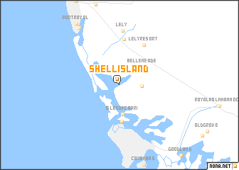
Shell Island (Florida, United States - USA)Shell Island is a town in the Florida region of United States - USA. An overview map of the region around Shell Island is displayed below.
regional and 3d topo map of Shell Island, United States - USA ::
Shell Island airports ::
The nearest airport is RSW - Fort Myers Southwest Florida Intl, located 56.8 km north of Shell Island.
Other airports nearby include MIA - Miami Intl (146.7 km east), HST - Homestead Arb (147.8 km south east), FLL - Fort Lauderdale Hollywood Intl (158.2 km east), NQX - Key West Nas (160.5 km south), Nearby towns ::
Old Marco Junction (3.2km east) //
Isles of Capri (4.6km south) //
Belle Meade (4.4km north east) //
Marco (5.8km south) //
Naples Manor (7.2km north) //
Lely Resort (7.2km north east) //
Lely (8.5km north) //
[all distances 'as the bird flies' and approximate] 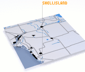 Places with similar names to Shell Island, United States - USA ::
// Shell Island (US)
Disclaimer :: Information on this page comes without warranty of any kind |
||
|
Where is Shell Island? Elevation and coordinates ::
Latitude (lat): 26°1'26"N Longitude (lon): 81°43'58"W
Elevation (approx.): 8m (map arrows pan, magnifying glasses zoom) |
||
|
Visiting Shell Island? Hotel/Accommodation ::
Book a hotel in Shell Island Travel Guide ::
rental cars ::
car rental offers GPS waypoint ::
download a GPX waypoint (PoI) of Shell Island for your GPS receiver
|
||